
Our Services
One flight, tailored to what you need to know about your land from a single field to a whole farm or catchment.
Crop Health Surveys
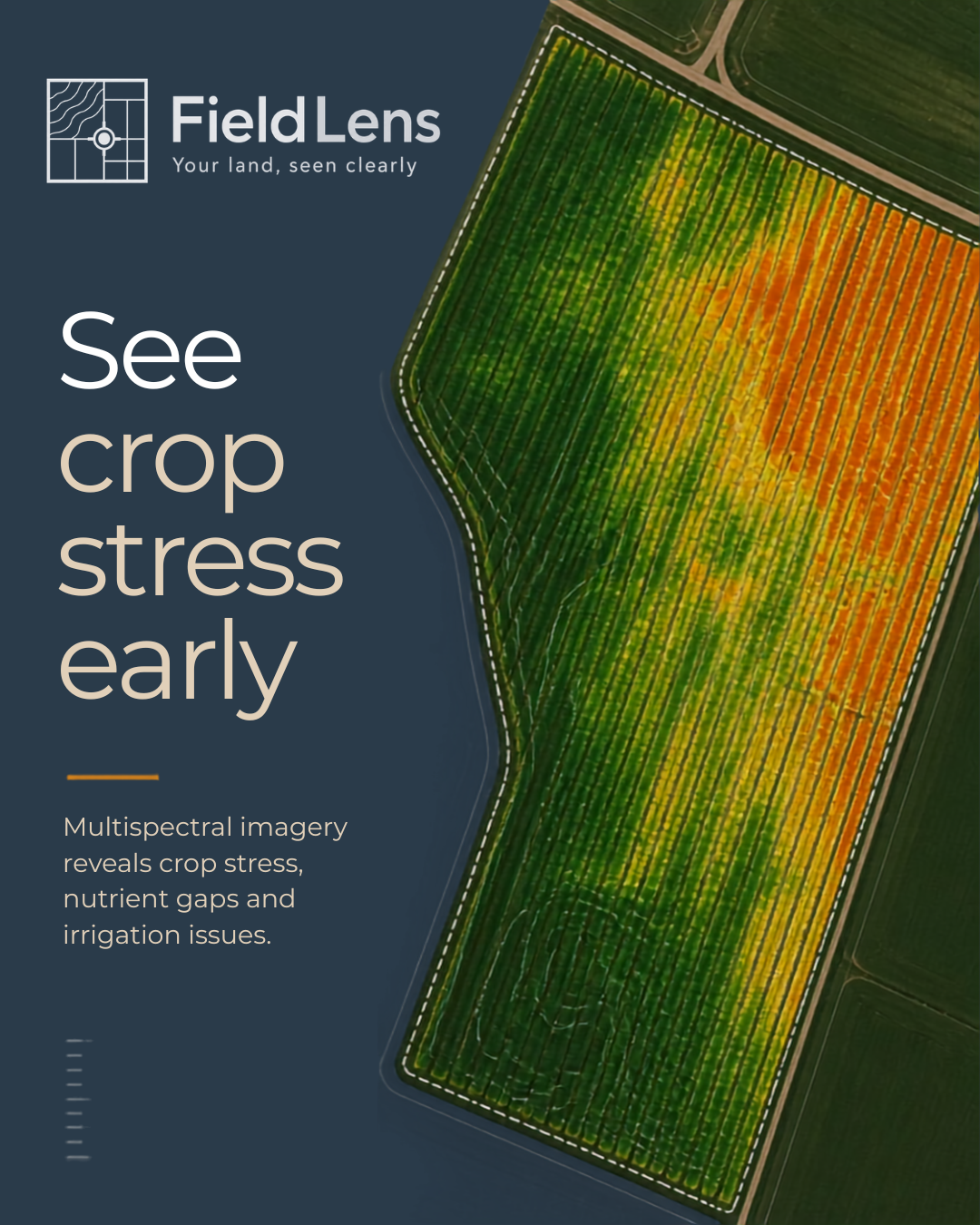
See crop stress early
Multispectral imagery reveals crop stress, nutrient gaps and irrigation issues, often before they're visible on the ground.
A multispectral flight captures NDVI, NDRE and GNDVI vegetation indices each highlighting a different aspect of plant health, from chlorophyll content to nitrogen status to canopy vigour. Together, they reveal variation invisible to the naked eye, giving a precise map of where stress is occurring and how severe it is.
Beyond diagnostics, into your equipment: the underlying data doesn't have to stop at a map you read and act on manually. It can be processed into a format compatible with GPS-guided farm equipment for variable-rate application. Applying fertiliser, pesticide or herbicide exactly where it's needed rather than applying a flat rate across the whole field. That means lower input costs and less product wasted on areas that don't need it.
When to book: real surveys open for spring 2027, in line with the growing season — get in touch now for an early slot.
Drainage Diagnostics
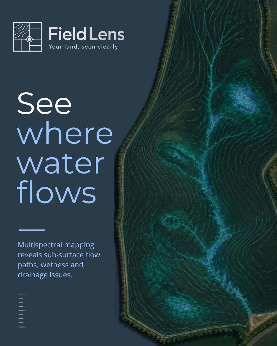
See where water goes
Drainage issues usually build for months before they're obvious from ground level — a blocked ditch, a compacted patch, a subsurface flow path that only shows itself as standing water after weeks of rain. By the time it's visible on a walk-around, it's often already affected yield, access, or machinery.
How it works: A survey flight captures high-resolution topographic and multispectral data across the site. That data is processed into flow accumulation maps, topographic wetness index, slope analysis and stream network mapping. Then layered together to identify exactly where water is pooling, where it should be flowing, and where the drainage system isn't doing its job.
What you receive: A map of priority drainage zones, GIS-ready layers, and a summary report containing enough detail to plan and budget repair work precisely, rather than committing to blanket drainage work across a whole field on guesswork.
Why it matters: Targeted intervention exactly where it's needed costs a fraction of blanket remedial work across a whole field. Knowing precisely where the problem sits turns drainage from a recurring annual cost into a one-off, targeted fix.
Priority season: October–February, when drainage problems are most visible and there's still time to act before conditions worsen.
When to book: Book ahead of the priority season to guarantee a survey slot.
Environmental Projects

See the bigger picture
Some questions can't be answered field by field. Understanding how water moves across a holding, tracking land-cover change over several years, or building an evidence base for stewardship schemes all require a landscape-scale view — something a ground survey or a single field walk simply can't provide.
How it works: A survey flight captures multispectral and topographic data across an entire holding, estate, or catchment area. That data is processed into a set of GIS layers: watershed and flow accumulation mapping showing how water moves across the terrain, slope and contour analysis identifying erosion risk or unsuitable land use, and land-cover classification distinguishing arable, pasture, woodland edge, and watercourses across the whole site.
What you receive: A full set of GIS-ready layers (hydrology, slope, land cover) alongside a summary map and report — structured so it can stand as a baseline record, be revisited in future years to track change, or be handed directly to an agronomist, land agent, or environmental advisor as supporting evidence.
Why it matters: Landscape-scale data supports decisions that field-level surveys can't: informing where a natural flood management intervention would be most effective, providing baseline documentation for agri-environment scheme applications (such as the Sustainable Farming Incentive), or simply giving an estate manager a clear, current picture of land condition across a holding without having to walk every boundary.
Repeatable, not one-off: Each survey produces the same structured GIS layers, a catchment survey flown now can be directly compared against one flown in future years — turning a single snapshot into an ongoing record of how the land is changing over time.
When to book: year-round, though best planned alongside your wider land management or scheme application calendar.